2008-06-13

Additional Photos for 20080613fr

Because the limit of photos was reached, a few additional (non-flood related) entries for the evening of June 13 were posted to the new GregoryCam live feed blog that has photos for June 2008.

Burlington Street Bridge still open

Water beginning to touch the bottom of the bridge.

Snake resting in the evening light

East Side of Iowa River

Water in parking area west of Madison street.

Iowa National Guard Under Water

An alternate location has been established.

Riverside Drive south of West Benton

Water is knee deep.

Riverside Drive

Riverside Drive

Gas Leak at Myrtle and Riverside

Iowa River begins covering Riverside Drive

Leaving the Mobile Hermitage

Going to survey Riverside Drive and then get provisions from west side
disaster co-location site.

Back at the Mobile Hermitage

Back at the Mobile Hermitage

Map of Willow Creek Trail and Clear Creek Trail

Willow Creek Trail

Willow Creek Trail is open from Mormon Trek and West Benton through to
Melrose Avenue by way of West High School.

Looking toward Camp Cardinal

Ashton Cross Country Field

South of Highway 1. On high ground, but very wet from recent rains.
Will continue north.

Clear Creek Trail is not accessible beyond the sports fields

Clear Creek Trail - The bicycle trail going from Hawkwye Court to Coralville

The first bridge is under water and the trail beyond is worse.

Painting

Information about the Mormon Handcart Park.

Plate 4

Information about the Mormon Handcart Park.

Plate 3

Information about the Mormon Handcart Park.

Plate 2

Information about the Mormon Handcart Park.

Plate 1

Information about the Mormon Handcart Park.

Bike Path

Visiting Mormon Handcart Park

The Mormon Handcart Park is west of Mormon Trek and accessible from the Hawkeye Court area. The trail in the park connects up with the Clear Creek Trail. These trails will probably be inaccessible within a few days.

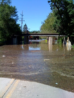
Mormon Trek looking north under railroad bridge south of 2nd Street / Highway 6

Water has reached Hawkeye Court apartments.

Mormon Trek is closed north of Melrose Avenue

Mormon Trek is closed to automobile traffic because the road is flooded before it connects with 2nd Street / Highway 1 in Coralville.

Rocky Shore Drive and Highway 6

Looking west toward Coralville.

Coralville Iowa now under about 5' of water

The above photo is a view looking west along 2nd Street / Highway 6 from the Corner of Rocky Shore Drive.

Riding to Coralville on 2nd Street / Highway 6 Near the Veterans Hospital

North Riverside Drive

Looking toward the art, theatre, and music buildings. Water seems to
be at about 5' covering the street.

Iowa Avenue Bridge Bike Path, flooded

This photo is at the north west corner of the Iowa Avenue bridge. The bicycle path that goes under the bridge had been flooded. The bridge was closed to automobile traffic, but bicycles and pedestrians were crossing it just fine.

Crossing the Burlington Street Bridge

There were reports that the Burlington Street Bridge would be closed at noon. Then a report that it would be closed at 3PM. Cars were still crossing after 5PM (see later photos of bridge).

Riding Home

At My Desk

Traffic on Prentis St. at Gilbert

By mid-day it was very difficult to get around Iowa City by car. Traffic was at a standstill on the available roads. The above photo shows cars that look like they are parked, but they are all in line stretched to the horizon waiting for the light to change. This view is looking west down Prentis Street from Gilbert Street.

Iowa River, Highway 6 Bridge

This is a view from the north east corner of the Highway 6 bridge looking west.

Looking east on Highway 6 from Iowa River

Just east of the Highway 6 bridge, on the east side of the Iowa River, the above view is looking to the east where the river started flowing over Highway 6. Hills Bank is the brown building in distance on the right. It was possible to continue east on Highway 6, but only through about 7 inches of water (or walking along the meridian in the middle).

South Gilbert Street, two blocks south of Highway 6

The above photo is a view looking west from South Gilbert Street (about two blocks south of Highway 6).

Gilbert Street / Waterfront Drive - South of Highway 6

Gilbert Street turns into Waterfront Drive just south of Highway 6. Hills Bank is to the right (not shown). This view is looking south toward the Aldi grocery store seen to the left.

Water Crossing Highway 6, east of Iowa River

The above photo is a view looking west toward the Highway 6 bridge from the east side of the Iowa River near Hills Bank.

Street Flooded

Looking west from Gilbert and Kirkwood. The water reached to the north west corner of the Aero rental store.

Burley Nomad Bicycle Trailer from World of Bikes

Just purchased a bicycle trailer.

Returning videos at ICPL

Had to ride back to the office, due to mistakenly grabbing the wrong
stack of videos.

Riding bicycle to Iowa City Public Library

Returning Rental Car, minutes before flood evacuation and road closings

Riverside Drive is now covered with water

Streets are being closed. The above photo is looking south east, driving on Riverside drive heading south just past the Burlington Street bridge.

Unloading Bicycles from Rental Car

Driving to office

On the Porch